
A potent nor’easter, characterized by heavy snowfall, blistering winds, and plummeting visibility, is currently sweeping across Nova Scotia and much of Atlantic Canada, causing extensive disruptions to daily life, travel, and essential services. The severe weather system has led to widespread school closures, significant travel cancellations, and left tens of thousands without power, underscoring the formidable challenges posed by winter storms in the region. As communities hunker down, emergency services and utility crews are on high alert, preparing for a protracted response to the storm’s multifaceted impacts.
The Anatomy of a Nor’easter: A Region Under Siege

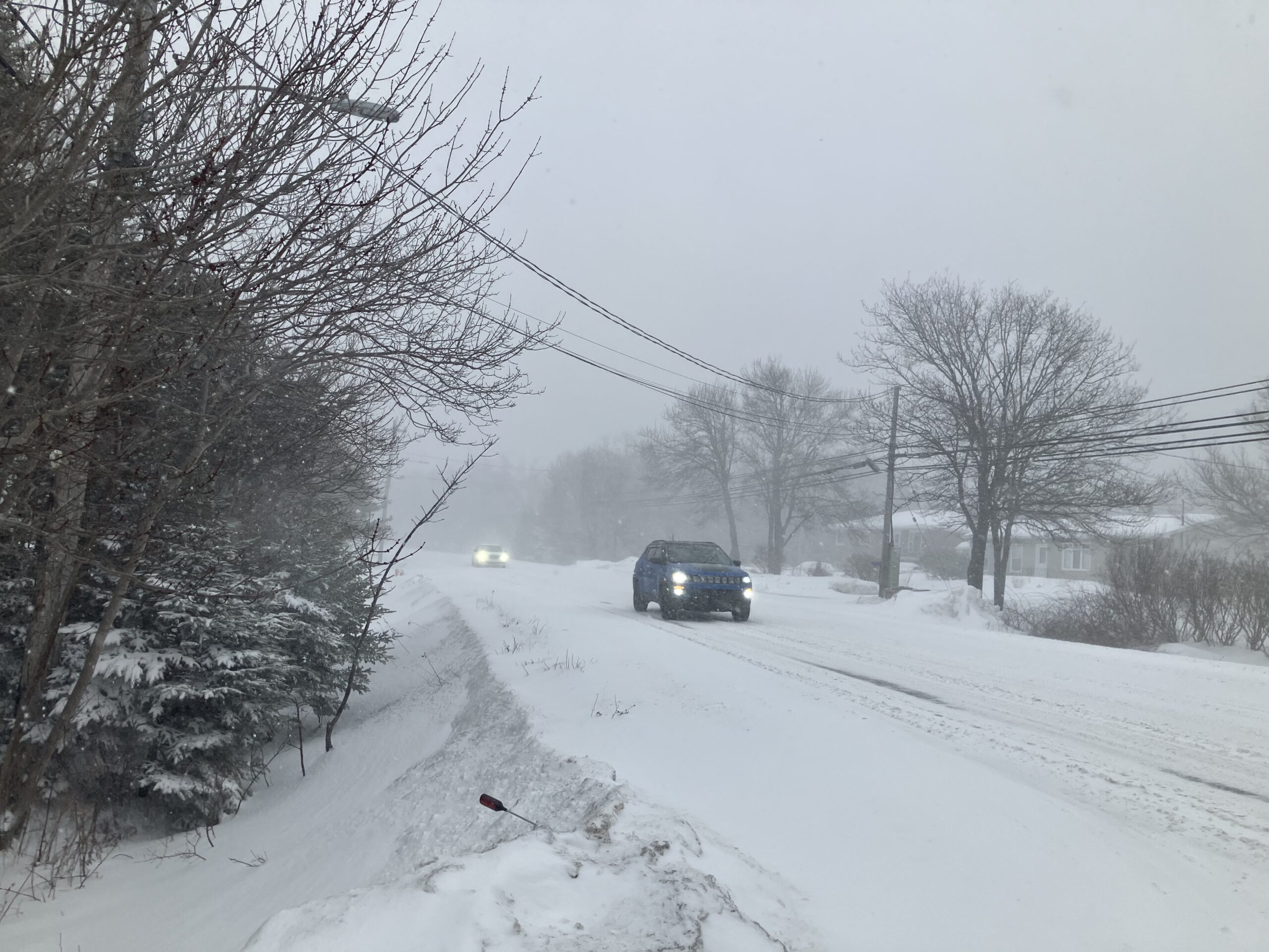
The current weather event is a classic nor’easter, a powerful low-pressure system that typically tracks along the eastern seaboard of North America, drawing moisture from the Atlantic Ocean and delivering heavy precipitation and strong winds to Atlantic Canada. These storms are notorious for their intense snowfall rates and severe winds, often creating blizzard-like conditions. This particular system began impacting the Maritimes early Monday, February 23, 2026, with conditions rapidly deteriorating throughout the day.
Environment and Climate Change Canada (ECCC) issued comprehensive winter storm warnings for Nova Scotia, New Brunswick, and Prince Edward Island, which remain in effect through Tuesday morning. These warnings highlight the significant hazards, including heavy snow, blowing snow, and strong wind gusts. For the southeast region of Nova Scotia, particularly Halifax and surrounding areas, forecasts predict substantial accumulations of between 30 and 50 centimeters of snow by dawn on Tuesday. Other areas across the Maritimes, including much of Prince Edward Island and southern and eastern New Brunswick, are expected to see significant snowfall totals ranging from 15 to 25 centimeters.
Adding to the perilous conditions are the formidable winds accompanying the storm. Wind gusts are anticipated to reach up to 80 kilometers per hour in many coastal areas and exposed inland regions. These strong winds, combined with the heavy snowfall, are drastically reducing visibility, creating whiteout conditions that make travel extremely dangerous, if not impossible. Bob Robichaud, a warning preparedness meteorologist with ECCC, emphasized the intensity of the storm, stating, "The higher accumulations and the higher snowfall rates are going to be in the afternoon and evening hours," indicating the peak impact period for many communities.

Immediate Impacts: Travel Gridlock and Power Outages
The storm’s arrival has brought immediate and far-reaching consequences. Transportation networks have been severely impacted, with air travel virtually grinding to a halt. Halifax Stanfield International Airport (YHZ), a critical hub for the region, announced the cancellation of all arriving and departing flights for the remainder of Monday, leaving hundreds of travelers stranded and causing ripple effects across national and international flight schedules. Passengers are advised to check with their respective airlines for updated information and rebooking options, as delays and cancellations are expected to persist into Tuesday.
On the ground, road conditions have become treacherous. Provincial police and local authorities have urged residents to avoid all non-essential travel. Major highways and secondary roads are experiencing rapidly accumulating snow and whiteout conditions due to blowing snow, making driving extremely hazardous. Plow operations are working continuously, but the intensity of the snowfall and strong winds are challenging their efforts to keep roads clear. Public transit systems in affected municipalities, including Halifax Transit, have also seen service reductions, detours, and cancellations, further complicating commutes for essential workers and those attempting to navigate the storm.

Perhaps one of the most immediate and widespread impacts has been on the power grid. Nova Scotia Power (NSP) activated its Emergency Operations Centre (EOC) at 8:00 a.m. AST on Monday, mobilizing crews from across the province and beyond to respond to anticipated outages. The utility company reported that the combination of heavy, wet snow weighing down trees and strong winds pulling branches onto power lines is the primary cause of service interruptions. As of Monday evening, tens of thousands of customers across Nova Scotia were without electricity, particularly in the hardest-hit southeastern regions. NSP spokesperson emphasized that crews are strategically positioned but warned that restoration efforts could be challenging and prolonged due to the severity of the weather and hazardous working conditions, including reduced visibility and high winds. Residents are advised to prepare for extended outages by having emergency kits ready, including flashlights, batteries, blankets, and a supply of food and water.
Educational Institutions and Community Preparedness
In anticipation of the severe weather, educational institutions across Nova Scotia implemented widespread closures and early dismissals. All public schools in the province were either closed for the entire day on Monday or released students early to ensure their safe return home before conditions deteriorated further. Universities and colleges, including Dalhousie University and Saint Mary’s University in Halifax, also cancelled classes and closed campuses, shifting to remote learning where possible. Similar measures were observed in parts of New Brunswick and Prince Edward Island, reflecting a coordinated effort to prioritize student and staff safety.

Provincial Emergency Management Offices (PEMO) in Nova Scotia, New Brunswick, and Prince Edward Island have been actively disseminating public safety advisories. Residents are strongly encouraged to stay indoors, avoid unnecessary travel, and ensure their emergency preparedness kits are fully stocked. Key recommendations include having enough food, water, and medication for at least 72 hours, fully charging cell phones and other electronic devices, and ensuring backup heating sources are safely operational. Furthermore, residents are cautioned against venturing out during the storm and to report downed power lines immediately to Nova Scotia Power or local emergency services, reminding everyone to treat all power lines as energized and dangerous.
A Winter of Contradictions: "Worse" Yet "Average"
This nor’easter arrives amidst a winter season that has been perceived by many Maritimers as particularly harsh, especially when contrasted with recent, milder winters. Indeed, data confirms that Halifax has already received approximately 50 centimeters more snow by this point in the winter compared to the same period last year. However, meteorologists offer a nuanced perspective on this perception.

Anthony Farnell, Global News’ chief meteorologist, provided valuable context, stating, "It is a worse winter than we’ve seen recently but actually pretty close to average compared to snow totals and there’s still quite a bit of winter to go." This analysis suggests that while the past few winters may have lulled residents into a false sense of milder conditions, the current winter is merely bringing the region closer to its historical average snowfall totals. The Maritimes are renowned for their robust winter weather, and significant snow events are a recurring feature of the climate. The increased frequency and intensity of storms this year, following a series of comparatively less snowy winters, might contribute to the feeling of an unusually severe season. This cyclical nature of winter weather patterns underscores the importance of ongoing preparedness and resilience in the face of variable climatic conditions.
Broader Regional Impact and Outlook
Beyond Nova Scotia, the nor’easter’s reach extends across the entirety of Atlantic Canada, affecting winter-weary residents in New Brunswick and Prince Edward Island. Both provinces are grappling with similar challenges, including significant snowfall, high winds, and resulting disruptions. Environment Canada’s warnings for these regions indicate widespread snowfall totals of 15 to 25 centimeters, accompanied by strong winds that are creating blowing snow and reduced visibility. Schools have been closed, transportation has been hampered, and power outages are being reported across both provinces, albeit perhaps not with the same intensity as the hardest-hit areas of Nova Scotia. Utility companies in New Brunswick (NB Power) and Prince Edward Island (Maritime Electric) have also activated their emergency protocols, deploying crews to address service interruptions.

As the storm progresses, the focus shifts to its duration and the subsequent recovery efforts. The heaviest snowfall and strongest winds are expected to persist through Monday night and into the early hours of Tuesday before the system gradually begins to track eastward and offshore. Conditions are anticipated to improve incrementally throughout Tuesday, with winds gradually diminishing and snowfall tapering off. However, the aftermath of the storm will present its own set of challenges, including extensive snow removal operations, ongoing power restoration efforts, and the need to clear transportation routes. Emergency services will continue to monitor the situation closely, providing updates and assistance as needed. The resilience of Maritime communities will once again be tested as they navigate the immediate impacts and subsequent recovery from this powerful winter storm, highlighting the enduring reality of life in Canada’s Atlantic provinces. The collaborative efforts of government agencies, utility providers, and community members will be crucial in mitigating the storm’s effects and restoring normalcy in the days to come.